LISLE
ARBORETUM CHRISTMAS BIRD COUNT
Count Circle Information
NEW IN 2015 THANKS TO CARL GIOMETTI!! Follow this link to a Google Map with the six count areas (plus the count dinner location) marked. Thanks, Carl!
https://www.google.com/maps/d/edit?mid=zZZYWY9PBpTQ.k8SJP04KKG2w&usp=sharing
The Lisle Arboretum Count
Circle is the 15 mile diameter area centered on the intersection of
Cass Avenue and 75th Street in Darien (Du Page County). Here is a map
showing the circle. There is also a larger version at the bottom of
this page.
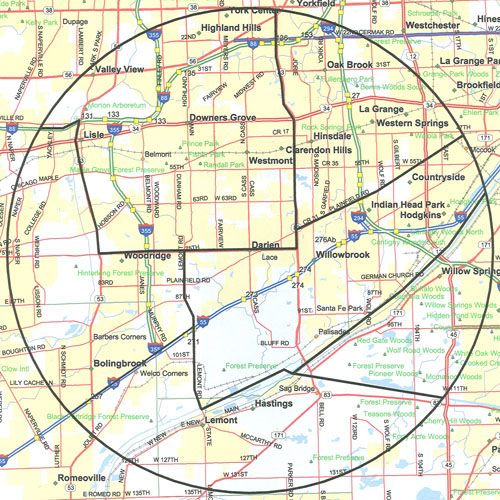
The map of the circle above shows the limits of the count circle and also shows how the circle is broken into six areas. Each area has assigned to it an "Area Coordinator" who oversees the group of birders whose territories are in that area. The areas are briefly described below.
-
Area 1:
-
This area in the northwest quadrant of the circle is bounded on by Rt 83 on the east, 75th Street on the south, Rt 53 to the west, and a bit of I-88 to its south out to the western edge of the circle. The main site in this area is the Morton Arboretum. Other important spots are Hidden Lake Forest Preserve, Lyman Woods, Belmont Prairie, and Maple Grove Forest Preserve. (Click here for a more detailed map of this area as a pdf file.)
-
Area 2:
-
This area in the western part of the circle is bounded starting at the north end by I-88, then Rt-53 south to 75th Street, east on 75th to Lemont Road, south on Lemont to I-55, then southwest along I-55 to the edge of the circle. The key birding locale of this area is Greene Valley Forest Preserve. (Click here for a more detailed map of this area as a pdf file.)
-
Area 3:
-
This area is in the northeast portion of the circle, bounded by Rt 83 on the west, south to Plainfield Road, then northeast to the edge of the circle. The important locations in this area are Bemis Woods Forest Preserve and Fullersburg Woods Forest Preserve. It also includes Wolf Road Prairie. (Click here for a more detailed map of this area as a pdf file.)
-
Area 4:
-
Occupying a central strip in the circle, Area 4's boundaries are Plainfield Road on its north down to Rt 83, south a bit on Rt 83 to 75th Street, then west on 75th to Lemont Road, south to the Des Plaines River, then northeast along the Des Plaines all the way to the circle's edge. This area is built around Argonne National Laboratory and Waterfall Glen Forest Preserve. There are also some interesting spots abong the Des Plaines River corridor. (Click here for a more detailed map of this area as a pdf file.)
-
Area 5:
-
This southeastern portion of the circle is bounded on the north by the Des Plaines River and on the south by the Calumet Sag Channel. Several locations within the Palos forest preserves lie in this area. Some key spots are Saganashkee Slough, Bullfrog Lake Forest Preserve, and the Little Red Schoolhouse. (Click here for a more detailed map of this area as a pdf file.)
-
Area 6:
-
This area forms the southern section, bounded on its north by I-55 to Lemont Road, south along Lemont Road to the Des Plaines River, then east to the Calumet Sag Channel, and southeast along the Cal-Sag to the circle's edge. This area also includes some of the Palos preserves, such as the expansive Cap Saeurs Holding, Swallow Cliff Forest Preserve, and a wealth of locations along the Des Plaines River and Cal-Sag Channel that remain open in cold weather. (Click here for a more detailed map of this area as a pdf file.)
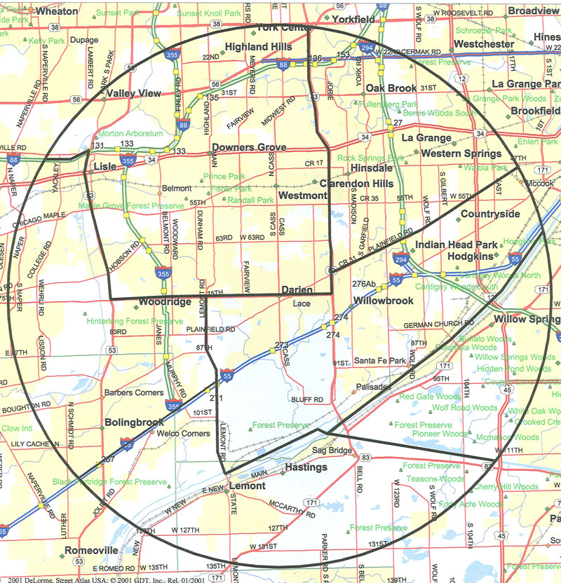
Here is a slightly larger version of the circle that shows street names and other detail in a more easy-to-read fashion.
You can try to Click here to open a Google Earth map with the Lisle-Arb CBC circle drawn on it, but this has not been working lately. If it does, you can navigate around, zooming in and out, to check out your territory. You'll need to have Google Earth installed on your computer; it can be downloaded for free at https://earth.google.com/